August 2026 edition · History
A Waterfall and a Watershed Moment
In pre-urbanized San Francisco, let’s say around 1776, there were two naturally attractive routes across the landscape from the north edge of the city to the basin-like valley containing the Mission District.
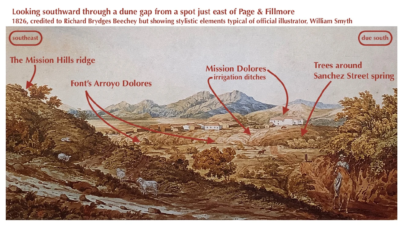
In pre-urbanized San Francisco, let’s say around 1776, there were two naturally attractive routes across the landscape from the north edge of the city to the basin-like valley containing the Mission District. Both entailed much effort trudging across sand and both sliced through the Lower Haight before flopping out of the dunes onto the “very good” “soil for planting” in the area of the Mission.
I pick this specific year for the reason that on March 29th of 1776 the Friday of Sorrows— Dolores in Spanish—a momentous decision was made by two appointed representatives of Spain. Though they didn’t get along especially well, their joint assessment, and the resulting actions of the Spanish settlers they instructed, are why we celebrate the 250th anniversary of our city this year, just as the country celebrates its 250th.
They concluded that water, soil, and Yelamu labor were all available to establish a farm along the south edge of our neighborhood. Farming (food, wool) was necessary, as no supply ships could be expected this far out on the edge of the Spanish Empire.
The deciders were Anza and Font, one the expedition leader (a military man) and the other the geographer (and a fastidious priest). They had camped beside Mountain Lake: still there, and after which Lake Street is named. They had then made their way through what we know as the Marina. Turning south, they followed the low area that is now Van Ness Avenue. To avoid marshy wetlands, they veered west of Civic Center arriving in the Lower Haight around Fillmore Street.
Anza, who had visited also on the previous day, noted in his journal that he saw a reliable spring, located most likely where Sanchez Street is today, half a block from Duboce Park. Font wrote more in his, describing the soils (quotes above) and naming the stream, Arroyo Dolores, that flowed from Anza’s spring. Font also wrote of the hill at the south end of a ridge (described and illustrated in my article last month). The creek flowed in an arc around this hill, into the lowlands and salty tidal marshes near where Rainbow Grocery is today. Erie Street was once Creek Street.
Father Font also specified that there was a waterfall.
It’s the only natural falls we have any evidence existed in the bounds of the city. Based on the geology of the now-flattened Lower Haight Ridge (a.k.a. Mission Hills) which they splashed over, the falls would have been near Ramona Avenue on 15th between Dolores and Guerrero.
Tracking these waterways isn’t simple. The creek was eradicated by diversion into farm ditches right away and the spring was the most likely of a possible few around the Lower Haight. Also, today’s waterscape is drier. We don’t know how wet the winters were just prior to our not-very-celebrated Founding Day. That would determine where and when water flowed, pooled, overflowed, and absorbed into (and leaked out of) the dunes. With such wide variance in weather conditions from year to year, and so little data, we are left to speculate on particulars.
In fact, even during the earliest years of San Francisco’s urbanization, at the Centennial celebration events in 1876, there was public debate about whether “Dolores” referenced any known body of water. We now know Anza’s spring and Font’s creek both were named for the Friday of Sorrows. Later, with the creek gone, the settlers who followed started calling something Lake Dolores which wasn’t even near the spring or creek, and wasn’t a true lake. Thanks to recent research, it’s clear that Laguna Dolores was a tidal inlet with marshy shores, over a rise at 18th Street and South Van Ness. Rumormongers have tried to reinvent it as a lake ever since (such as a false map at Camp & Albion Streets).
I began by mentioning a second route through the dunes into and through the Lower Haight. This path came across near Scott Street and will be the topic of the next installment of our Lower Haight Local history.