July 2026 edition · History
Upon a Ridge
If you’re a bicyclist and have explored our neighborhood, you don’t need to be told where the hills are or where to go to avoid them.
If you’re a bicyclist and have explored our neighborhood, you don’t need to be told where the hills are or where to go to avoid them. The place is not Kansas. Even so, many of us cycling along are stuck viewing the Lower Haight essentially in two dimensions, as a grid of streets.
That’s simple to explain, of course. The streets are our access. To. Around. Through. Past. And where there’s a hill, the street ramps up, down, but you’re still on the grid, conceiving it as a street network. Though nonplanar, it facilitates two dimensions of movement.
As for me, I am no longer living on that plane. Maybe I’m below. On the downs, I flow. I am a flower with pedals (occasionally wearing a flower with petals). As flowers (or flow-ers, if you prefer), we ride the streets in parallel with a grid of sewers, underneath—the first big construction project of the neighborhood, carried out in the 1870s.
If you feel aversion to sewers, then instead imagine yourself flowing as the spattering rain. It gushes in the gutters, storm runoff, eventually trapped into the rain garden (a.k.a. bioswale), soaking into the sandy soil below. Still, much of it goes into the sewers via catch basin drains. If you insist on altogether avoiding your kinship with the wastewater, take this advice: ally with an ancient creek, like the one depicted in the Duboce bikeway mural. Ancient waterways didn’t adhere to the street-and-sewer grid. Be free!
There’s also above. When I loose myself from the grid, sometimes I’m up there. I invite you: for a moment, unbind yourself from the surface altogether.
Without flappy wings or a jet pack, you could miss overall patterns found in the up dimension. But come! The ridges and valleys and how they define the Lower Haight are easily seen. Follow me!
Come to the end of Scott Street, cross Duboce and you are confronted by a concrete wall. Note the fence atop it. It is a bland, unadorned terrace that you no longer have permission to ignore. Ascend the driveway to your right and head to the far reaches of that terrace.
From here it’s unmistakeable: The Lower Haight is defined by a ridge that runs NW by SE, like so much of the city.
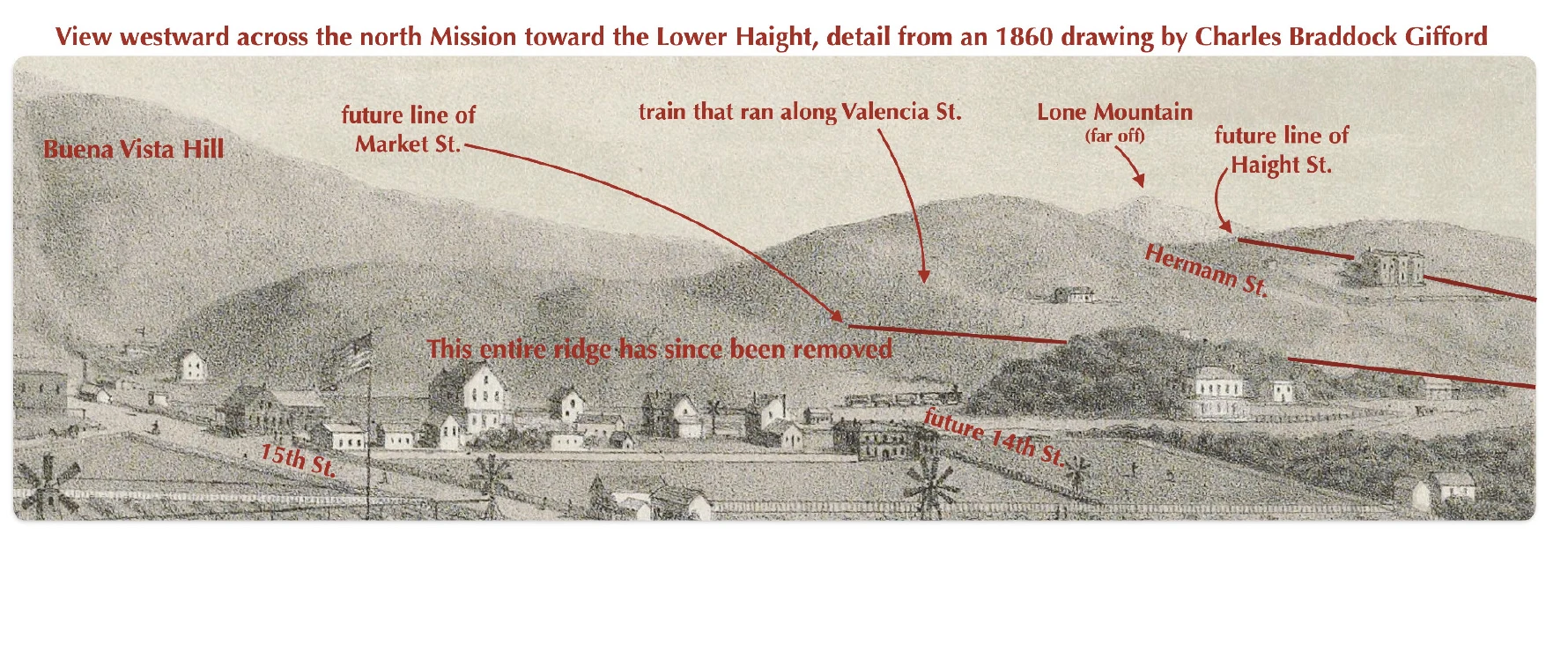
Until steam shovels and crews of laborers with wheelbarrows attacked it, that ridge was more dramatic, repeatedly removed, reduced, down and down. Now one blip of it pokes up (only a little) above Market Street, level with the adjoining blocks to the north. But it was once very high, towering over the Mission District. When this area was still rural, the bumps of this ridge were known as “the Mission Hills.”
Where exactly was it? Look due eastward from your perch. See that tall Safeway sign? The ridge of greenish bedrock that hefts Alamo Square and Fell Street Hill, the shoulder that Haight Street glides over, to your left, at one time extended to your right more than a block past that Safeway sign, dropping down abruptly at 15th Street. It was tall and it was long. Market Street was cut through it, then Dolores. Eventually Duboce and the others.
There was another ridge, too. It was one block wide before blocks existed, made entirely of sand, part of a vast dune landscape that extended from here to the Presidio and Pac Heights. It shrugged down off Buena Vista, its high points running 40 to 60 feet above today’s Page Street, from the Upper Haight all the way to Fillmore where there was a gap. After that it continued downslope to the bay. The whole length of it formed something of a border between passable soils (south) and dune sand (north). Scrubby plants grew on it. It was flattened in the 1860s and 1870s to make way for streets. And sewers!